| Home | Airport Location | Local Motels & Restaurants | Litchfield Aerial Photos | Young Eagles |
 Click on Picture for larger view. |
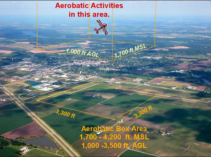
Warning! Aerobatic Activities directly over airport.
Check Notams for current activity.
Aircraft operating at landing pattern altitude (1500 ft. MSL or 800 ft. AGL) will not conflict with Aerobatic activities, just be alert to aircraft in the pattern!
Field Elevation: 690 ft. MSL
Unicom Frequency: 122.8
GPS approaches for runway 9/27 and RNAV(GPS) for runway 18/36.
The NDB has been taken out-of-service. Check charts for details.
AWOS INFORMATION
Phone number: (217) 324-4735
Frequency: 118.175 MHZ
| RADIO NAVIGATION |
| Vandalia VOR 114.30 |
| Civic Memoral (Alton) 263 |
| Troy VOR 116.00 |
| Taylorville 395 |
Runway 9/27 is 3,901 feet long and 75 feet wide and 12,500 pounds single wheel loading (SWL) 25,000 pounds dual wheel loading (DWL)
Runway 18/36 is 4,003 feet long and 75 feet wide and 12,500 pounds single wheel loading (SWL) 25,000 pounds dual wheel loading (DWL)
RUNWAY THRESHOLD INFORMATION
No Displaced Thresholds
| Runway | Latitude North | LongitudeWest | Elevation |
| 9 | 39:10:02.50 39.16736111 |
089:41:01.96 -89.68387778 |
682 feet |
| 18 | 39:09:47.66 39.16323889 |
089:40:20.51 -89.67236389 |
685 feet |
| 27 | 39:10:02.49 39.16735833 |
089:40:12.44 -89.67012222 |
690 feet |
| 36 | 39:09:08.10 39.15225000 |
089:40:20.30 -89.67230556 |
680 feet |
FLIGHT SERVICE
Saint Louis Flight Service Station Phone Number: 1-800-WX-BRIEF (1-800-992-7433)
NIGHT FLYING
Key radio on the unicom frequency 122.8 to change the intensity of the airport lights at night.
Runway 18/36 PAPI and runway 9/27 PAPI can be keyed up during daylight hours.
Click Here for details
This web site was designed and programmed by Jim Wright. Copyright © J.A.C.E. 2004
For more information send e-mail to the Litchfield Airport Authority